While a significant part of the planet relies on Google Maps for navigation, it's not a secret that Google's software sometimes shows its limits.
It's a fantastic piece of software that helps you find a faster and more convenient route to a destination, but the tiniest map error can turn a simple journey into a major nightmare.
Google Maps is also useless when you leave the paved road. While other software developers tried to fill the gap and focused on off-road navigation, nobody has come up with an application that offers a flawless experience.
General Motors believes the only way to get accurate navigation in off-road is with a drone. It sounds crazy, but The General patented a system that would allow a drone to dock and undock from a vehicle specifically to scan the road ahead.
While this isn't the first time we hear about drones "parked" on vehicles, GM thinks a flying machine could help collect precious information to help the driver navigate in off-road mode.
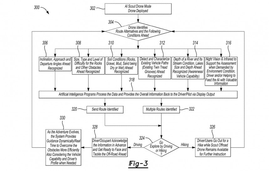
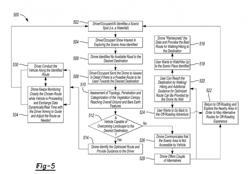
It all starts with the driver enabling a so-called AI Scout Drone mode. When this feature is activated, the vehicle traveling on an off-road route deploys a drone that starts scanning the road ahead and looks for ways to reach the destination. However, the most important bit is how it determines the optimal route.
GM says a drone could determine essential off-road route conditions, including inclination, approach and departure angles, size, type, and level of difficulty for the rocks and other obstacles, and soil conditions such as rocks, gravel, mud, and sand being dry or wet, and possible vehicle paths – this would come in particularly handy during off-road adventures when more vehicles would attempt to pass through difficult terrain.
When it collects all this data, the drone allows an AI-powered system to generate one or multiple routes. These are transmitted to the vehicle, with the driver allowed to choose between the available routes displayed on the infotainment screen using a color-coded system. The green route is the recommended one, while the yellow and the red are the more difficult alternatives based on the factors mentioned earlier.
The routing engine is more complex than in Google Maps and considers additional information collected from the vehicle, including its size and, more importantly, the driver's skills on difficult terrain. If the driver previously struggled to go through a similar route, the drone could look for more convenient alternatives that the driver would be able to use without risking getting stuck or worse.
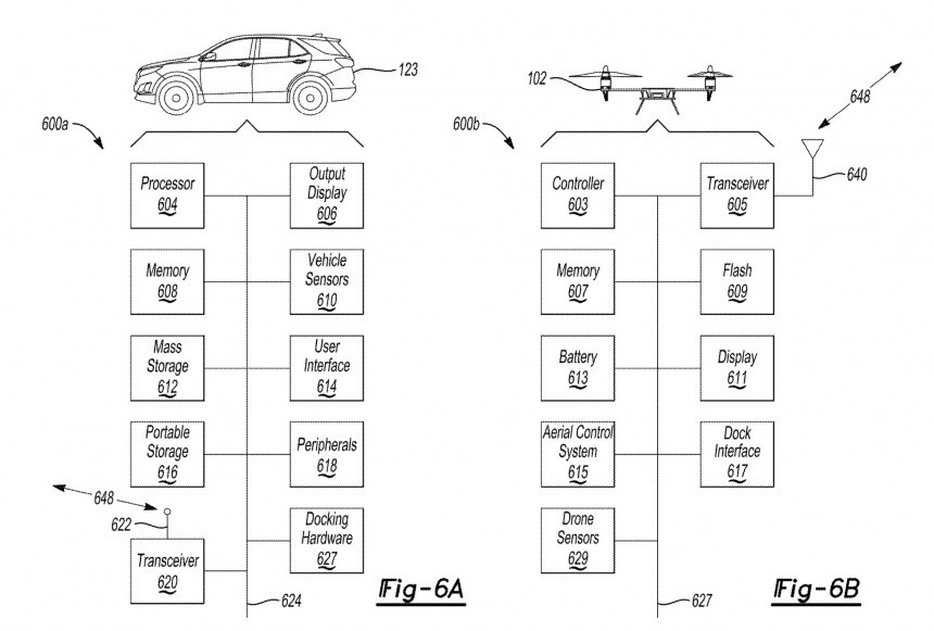
Eventually, the drone would combine topography with data provided by the vehicle, generating routes that match every driver and their skills. GM explained that the connection between the drone and the vehicle would work as a client-server data exchange, and they could continue providing information to each other for more accurate route generation.
For example, the vehicle can provide data from its sensors, including the battery level – I know that off-roading in an electric car is blasphemy for many of you, but GM plans to go all-in on EVs by the end of the next decade. The drone would receive battery information and look for routes that would allow the vehicle to reach the destination based on the existing terrain.
In plain English, the drone will try to estimate how much power the vehicle will use when going on a suggested route, compare it to the existing range, and eventually determine if the route can be used. In some cases, it could also look for available charging stations and add them to navigation if the battery level doesn't allow a vehicle to reach the final point. This system works similarly to the Google Maps integration on Android Automotive, where the navigation app suggests routes and automatic stops for charging based on the battery level.
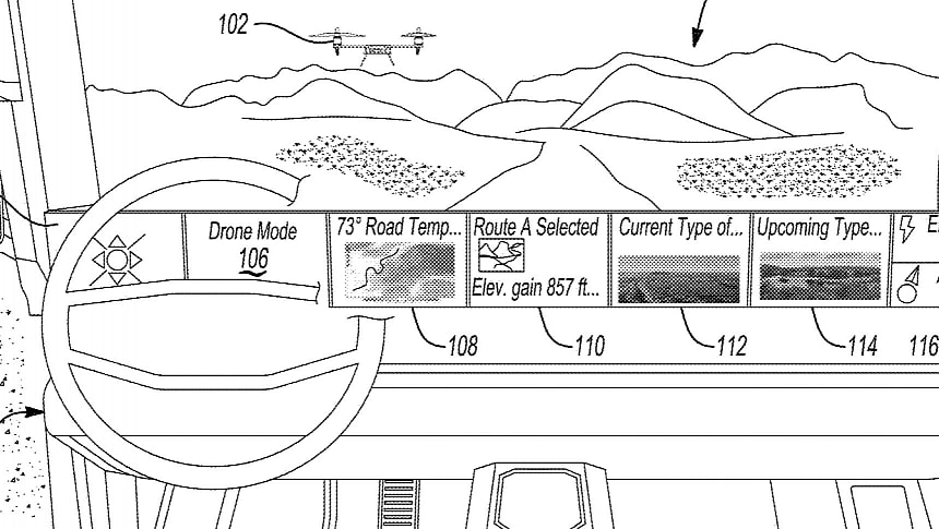
GM also envisions a custom dashboard style when the drone is deployed. The instrument cluster would display a message informing the driver that they are navigating in "drone mode," with the other screens on the dashboard displaying the road temperature, the selected route, elevation, the current and upcoming types of terrain, energy management information, and whether an alternative route is available.
Drivers will always be in full control of the routing system, so when the drone finds a new route and displays it on the dashboard, only the driver or another vehicle occupant can enable it.
GM's patent application includes many other technical details, including how the drone would exchange data with the vehicle, and you can check out all the information using in the document attached at the end of the article. Meanwhile, it's essential to remember that GM's idea is still in the patent stage, so there is no guarantee that the company will eventually promote it to the mass production stage. Carmakers sometimes patent their idea just to make sure others don't steal them, and this could be the case with GM's crazy drone-powered off-road navigation system, too.
Google Maps is also useless when you leave the paved road. While other software developers tried to fill the gap and focused on off-road navigation, nobody has come up with an application that offers a flawless experience.
General Motors believes the only way to get accurate navigation in off-road is with a drone. It sounds crazy, but The General patented a system that would allow a drone to dock and undock from a vehicle specifically to scan the road ahead.
While this isn't the first time we hear about drones "parked" on vehicles, GM thinks a flying machine could help collect precious information to help the driver navigate in off-road mode.
GM says a drone could determine essential off-road route conditions, including inclination, approach and departure angles, size, type, and level of difficulty for the rocks and other obstacles, and soil conditions such as rocks, gravel, mud, and sand being dry or wet, and possible vehicle paths – this would come in particularly handy during off-road adventures when more vehicles would attempt to pass through difficult terrain.
When it collects all this data, the drone allows an AI-powered system to generate one or multiple routes. These are transmitted to the vehicle, with the driver allowed to choose between the available routes displayed on the infotainment screen using a color-coded system. The green route is the recommended one, while the yellow and the red are the more difficult alternatives based on the factors mentioned earlier.
The routing engine is more complex than in Google Maps and considers additional information collected from the vehicle, including its size and, more importantly, the driver's skills on difficult terrain. If the driver previously struggled to go through a similar route, the drone could look for more convenient alternatives that the driver would be able to use without risking getting stuck or worse.
Eventually, the drone would combine topography with data provided by the vehicle, generating routes that match every driver and their skills. GM explained that the connection between the drone and the vehicle would work as a client-server data exchange, and they could continue providing information to each other for more accurate route generation.
In plain English, the drone will try to estimate how much power the vehicle will use when going on a suggested route, compare it to the existing range, and eventually determine if the route can be used. In some cases, it could also look for available charging stations and add them to navigation if the battery level doesn't allow a vehicle to reach the final point. This system works similarly to the Google Maps integration on Android Automotive, where the navigation app suggests routes and automatic stops for charging based on the battery level.
GM also envisions a custom dashboard style when the drone is deployed. The instrument cluster would display a message informing the driver that they are navigating in "drone mode," with the other screens on the dashboard displaying the road temperature, the selected route, elevation, the current and upcoming types of terrain, energy management information, and whether an alternative route is available.
GM's patent application includes many other technical details, including how the drone would exchange data with the vehicle, and you can check out all the information using in the document attached at the end of the article. Meanwhile, it's essential to remember that GM's idea is still in the patent stage, so there is no guarantee that the company will eventually promote it to the mass production stage. Carmakers sometimes patent their idea just to make sure others don't steal them, and this could be the case with GM's crazy drone-powered off-road navigation system, too.


